01 / Software workflow
Start with a defined audience and output.
Polycam supports reconstruction from drone photographs or footage. Our completed property reconstruction shows how building exteriors, roofs and surrounding site features can be brought together in one scene. A remote property review, a presentation scene and a model intended for another application may each favor a different capture and delivery plan.
Explain how the result will be used and who will open it. If the goal is a shareable scene, discuss the intended viewers and access. If the goal is a file for downstream work, specify the receiving application and format. Processing, viewing access, exports and any subscription requirements are confirmed as part of the project scope.
02 / Software workflow
Choose the reconstruction for its job.
Polycam offers photogrammetry meshes and Gaussian splats. A mesh represents surfaces with polygonal geometry; a splat prioritizes the appearance of the reconstructed scene. The choice should follow the required use rather than the most impressive opening view.
For example, a visual tour may prioritize a convincing view from several positions. A geometry handoff needs a clear understanding of what can be exported and checked. If a proposal includes both, name both products and explain which one is primary. Do not assume a beautiful scene is automatically a checked measurement record or a native design model.
03 / Software workflow
Keep processing inputs separate from website media.
Polycam uses original GPS and camera metadata for model placement and scale. Its drone workflow processes photo and video inputs as separate captures. Keep the technical originals available for the processing plan; a reduced website image with stripped metadata serves a different purpose.
Use a private working archive that preserves the relationship between the capture date, input files and selected processing version. Create public examples separately, removing sensitive location information where appropriate. Before uploading client material, agree the processing account, access and sharing audience. A private technical dataset and a public portfolio scene should never be treated as the same permission decision.
Source: Polycam: Creating drone 3D models
04 / Software workflow
Agree the export before promising the handoff.
Export availability varies by capture mode and subscription. Polycam documents mesh formats such as OBJ, FBX and GLTF, with point-cloud exports depending on the appropriate plan. A format should be confirmed against the current account and the actual receiving application, rather than copied from a general feature list.
Ask the recipient to test a representative file before a large delivery. Confirm units, orientation, texture paths and whether companion files are required. A browser-friendly viewing copy can be useful for discussion while a separate agreed export serves downstream work. Record which version is intended for which use so the customer does not have to infer that from filenames.
Source: Polycam: Export formats and subscription availability
05 / Software workflow
A measurement button is not the acceptance test.
Polycam’s current volume tool is limited to supported mesh-based captures and eligible plans; Gaussian splats are not supported for that calculation. The tool also requires attention to model units and the selected geometry. Those limits illustrate why the model type and intended measurement must be defined together.
If the assignment needs a quantity, explain what the quantity represents, how the base or boundary is defined and what independent information can check it. Agree the tolerance and reporting method separately from the software choice. Avoid applying a vendor’s example percentage to a different site or dataset. The useful result is a checked answer to the project question, not simply a number shown by an interface.
Source: Polycam: Volume measurement: supported captures and units
06 / Software workflow
Explore a completed property reconstruction.
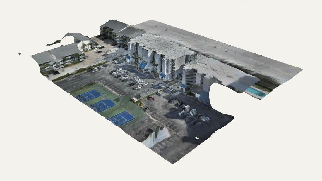
Our public example connects a multistorey building, its roof surfaces, parking areas and recreation space in an explorable scene. That connected view helps a remote reviewer understand how the visible parts of a property relate to one another, rather than piecing the layout together from separate photographs. Selected photographs can still provide closer detail where a specific feature matters.
Our completed work also includes a property reconstruction with an Iron Red thermal-palette texture, adding another way to discuss the visible roof, facade and grounds. The palette colors are part of the displayed texture; this example is not a radiometric temperature dataset, a verified thermal orthomosaic or a diagnostic finding. The visible and thermal-palette versions use different source captures and are not presented as aligned overlays or a measured comparison between dates.
The example also shows why review matters: gaps and incomplete surfaces are visible around parts of the reconstruction. A realistic texture does not establish geometric accuracy or reveal hidden conditions. Use the scene as a visual reference; any measurement, coordinate requirement or specialist assessment needs a separately agreed checking method and scope.
07 / Software workflow
Use a pilot scene to settle practical questions.
A small representative capture can test the proposed route from imagery to recipient. Review whether the required surfaces appear, whether the scene opens on the intended device and whether the requested export is usable. Identify limitations before expanding the area or promising a particular presentation.
Send Fly Maxwell the subject, location, intended use, preferred application and deadline. If you have an existing Polycam workflow, describe the account and handoff requirements without sharing credentials in the project brief. The proposal can then identify capture, processing, delivery and any recurring needs. That is the difference between trying a tool and planning a useful project around it.
VERIFY THE DETAILS / KEEP EXPLORING
Sources & further reading
Original explanation by Fly Maxwell. Technical and regulatory details are linked to the responsible organizations below. Product features, software plans and operating rules can change; check the current source when planning a project or a flight.
- Drone photo and video reconstruction Polycam · reviewed October 8, 2026
- Photogrammetry meshes and Gaussian splats Polycam · reviewed October 8, 2026
- Creating drone 3D models Polycam · reviewed October 8, 2026
- Export formats and subscription availability Polycam · reviewed October 8, 2026
- Volume measurement: supported captures and units Polycam · reviewed October 8, 2026
Manufacturer specifications describe the product under stated conditions. They are not a promise of project accuracy, flight duration, target detection or a particular outcome.