A photograph gives you a viewpoint. A reconstruction connects viewpoints into a place you can explore. See how our visible-light and thermal imagery becomes a shared visual reference.
Explore a visible-light scene and two thermal-palette versions from our property capture archive.
01 / ACTUAL RECONSTRUCTION
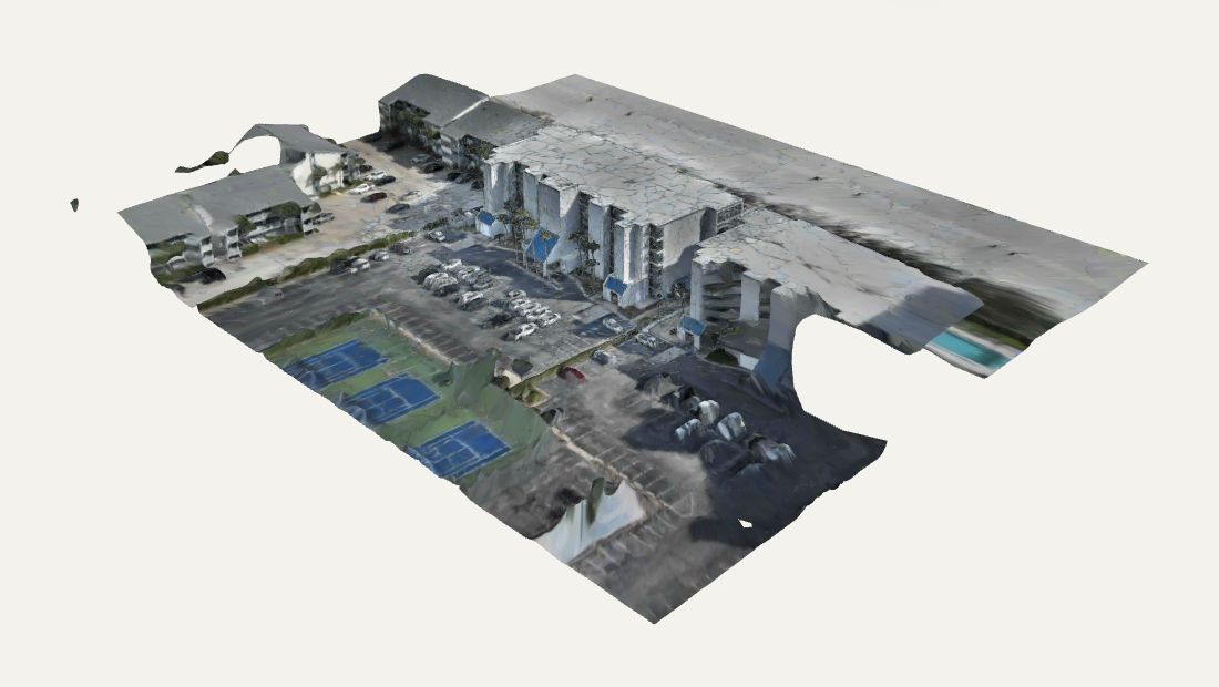
VISIBLE-LIGHT RECONSTRUCTION
The property, connected
Follow the relationship between the roof, facade and surrounding grounds. This completed exterior reconstruction brings many viewpoints into one scene for remote discussion and visual orientation.
Processed from 1,540 source frames. Capture record: May 20, 2026. Areas beyond the captured coverage have gaps or incomplete surfaces.
Select Explore to load the external viewer. Drag to rotate, and use the viewer controls to pan or zoom.
Captured by Fly Maxwell · Reconstruction and interactive viewer by Polycam ↗
02 / ACTUAL RECONSTRUCTION
IRON RED / THERMAL-PALETTE RECONSTRUCTION
Thermal patterns in spatial context
Explore a completed reconstruction with thermal-palette imagery across the roof, facade and grounds. The connected scene helps communicate where a visible pattern sits on the property.
A palette-textured visual model. The colors are not a calibrated temperature scale or a finding of moisture, damage or an equipment fault.
Select Explore to load the external viewer. Drag to rotate, and use the viewer controls to pan or zoom.
Captured by Fly Maxwell · Reconstruction and interactive viewer by Polycam ↗
03 / ACTUAL RECONSTRUCTION
WHITE HOT / THERMAL-PALETTE RECONSTRUCTION
Another way to read the scene
A grayscale thermal presentation provides another view of the property’s surfaces. Explore the shape and image patterns, then connect any observation with the source imagery and the project question.
These are separate reconstruction versions. Their viewpoints, textures and geometry are not presented as an aligned comparison or a measured change over time.
Select Explore to load the external viewer. Drag to rotate, and use the viewer controls to pan or zoom.
Captured by Fly Maxwell · Reconstruction and interactive viewer by Polycam ↗
THE VALUE IS IN THE NEXT CONVERSATION
Bring the place into the discussion.
A connected scene can give owners, contractors and remote teams a common visual reference. Define the decision first, then choose the capture and delivery around it.
01 / ORIENT
Find the area together.
Move from the whole property toward a roof or facade. Discuss what is visible and use selected stills to keep the relevant area in a project record.
02 / COMMUNICATE
Explain the observation.
Connect a source photograph or thermal pattern with its surroundings. A model adds spatial context; the original image and capture conditions remain part of the evidence.
03 / HAND OFF
Choose a useful format.
Discuss browser viewing access, selected stills, a presentation or an agreed model export. Confirm compatibility, units, access permissions and any validation the receiving team requires.
CAPTURE → CONTEXT → A USEFUL RECORD
A flight ends. The record keeps working.
Bradley uses Liberty Shield Hub to connect property imagery, 3D viewing resources, thermal documentation and reviewed reports. See how that workflow helps the next conversation—and the next visit.
Portal access, reports and recurring visits are agreed for your project.
01
Capture
Photographs, video and agreed specialist imagery
02
Connect
Property areas and available 3D viewing resources
03
Review
Visible context, thermal documentation and observations
04
Report
An approved record for the intended audience
05
Return
Inspection history and a brief for the next visit
READ THE MODEL WITH CONFIDENCE
Know what the view can tell you.
These are completed visual reconstructions, with real capture boundaries, gaps and surface artifacts. A smooth texture does not establish geometric accuracy, reveal hidden conditions or turn the model into a survey or engineering assessment.
The thermal examples use palette imagery as model textures. They are not presented as radiometric temperature datasets, thermal orthomosaics, a registered visible/thermal overlay or a diagnosis. Those products need their own source data, processing and checks.
Interactive viewers are provided by Polycam and load only after you select Explore. Polycam may receive technical visit information and use its own storage or cookies. You can use the local stills without loading a viewer. Privacy details.
Send the city and state, priority surfaces, intended use, receiving software and deadline. We’ll discuss capture coverage, viewing access, deliverables and the checks your assignment needs.