
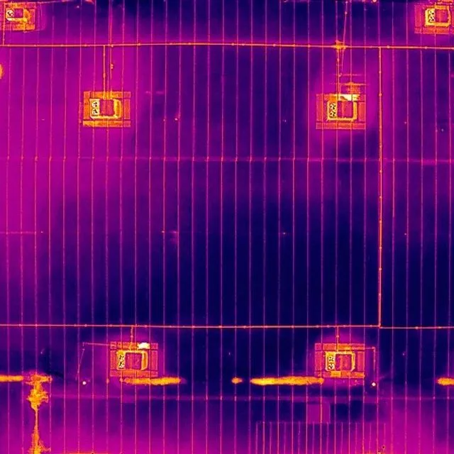
01 / Thermal mapping
Name the thermal product precisely
A display mosaic can provide an overview of thermal appearance. A radiometric thermal workflow aims to retain information used for temperature analysis across a georeferenced area. The word “thermal map” alone does not specify which result is being delivered, what numerical information survives processing or what a recipient can do with it.
Start with the intended use. If an owner needs to locate a pattern for follow-up, a well-organized visual record may be enough. If a reviewer needs to analyze temperature values later, the required original data, parameters, software and export need to be agreed on. These decisions belong in the scope, before a flight produces files that cannot support the intended workflow.
02 / Thermal mapping
Preserve the data, not just the appearance
Radiometric thermal formats contain information beyond a colorized display image. An ordinary thermal JPEG may contain only the displayed colors. Renaming it or stitching it into a larger picture does not recreate the missing radiometric data. File compatibility also depends on the camera, metadata and processing software, not simply on a .jpg extension.
Treat original capture files as evidence. Keep them separate from edited web images and presentation exports. Confirm which metadata the analysis workflow requires before optimizing or converting them. A small, convenient file can be useful for communication, but it should not silently replace the source file needed for subsequent analysis.
Source: Pix4D: Thermal images and radiometric formats in PIX4Dmatic
03 / Thermal mapping
Workflow requirements are specific, not universal
DJI’s July 2026 Terra thermal reconstruction workflow uses paired visible and thermal imagery, with visible images supporting aerial triangulation. Its guidance warns against low-light capture for that particular process and sets workflow-specific planning requirements. Other software publishes different acquisition guidance. There is no single overlap percentage or camera setting that should be copied across every thermal mapping project.
Confirm a tested path from camera to processing to recipient. Ask whether the exact camera, file type and software version are supported. Establish how the map is located, which parameters affect its values and how the output will be checked. A product announcement is evidence of a capability in that vendor’s workflow; it is not evidence that any operator has the equipment, subscription or tested process to deliver it.
Source: DJI Enterprise: DJI Terra Thermal 2D Reconstruction: July 2026 Update
04 / Thermal mapping
Capture for the thermal question, not only the visible picture
A visible overview can look excellent while the thermal detail needed for the task is insufficient. Define the smallest feature or pattern that matters, the area to be covered and the context required for interpretation. Then let the operator evaluate a suitable capture plan and whether the project is feasible under the actual conditions.
For a large property, coverage should be documented in a way the recipient can understand. Divide the area into useful references, track completed sections and mark gaps. If collection spans changing conditions, record that fact. A joined map can make an area look uniform even when the underlying observations were made at different times or under different circumstances.
05 / Thermal mapping
A mapped pattern still needs a careful explanation
Location improves the usefulness of an observation: a maintenance team can discuss the same area without guessing which frame shows it. But mapping does not turn a thermal pattern into proof of a particular failure. The same discipline used for individual thermal images still applies: distinguish the observation, the interpretation and the next verification step.
An illustrative report might identify several areas for review, link each area to a visible image and an original thermal frame, and state the collection conditions. A qualified specialist can then examine the named locations in context. A map should make this process easier, not encourage a reviewer to draw stronger conclusions than the evidence supports.
06 / Thermal mapping
Specify the handoff before choosing the flight
Ask the recipient how the output will be used and what needs to remain editable or analyzable. A presentation map, an original dataset and an analysis-ready export can all have a place in a project, but they should be labeled clearly. Include a plain-language explanation of what was preserved, what was transformed and which limitations remain.
A strong scope makes the result inspectable. The client should be able to verify that the intended area was covered, that the files can be opened and that the observation identifiers connect back to the supporting material. This turns a visually impressive map into a practical record that another person can review and reuse.
- Intended visual or numerical use of the thermal output.
- Supported camera, original file format and processing workflow.
- Required location references, units and viewing tools.
- Capture conditions, coverage gaps and quality review.
- Associated visible imagery and original-frame references.
VERIFY THE DETAILS / KEEP EXPLORING
Sources & further reading
Original explanation by Fly Maxwell. Technical and regulatory details are linked to the responsible organizations below. Product features, software plans and operating rules can change; check the current source when planning a project or a flight.
- Thermal images and radiometric formats in PIX4Dmatic Pix4D · reviewed October 8, 2026
- DJI Terra Thermal 2D Reconstruction: July 2026 Update DJI Enterprise · reviewed October 8, 2026
Manufacturer specifications describe the product under stated conditions. They are not a promise of project accuracy, flight duration, target detection or a particular outcome.